|
Mae Hong Son (แม่ฮ่องสอน)
The small capital of a
jangwat of the same name in Northwest Thailand (map), at 924 kms
from
Bangkok and
by mountain road over Pai, 1,864 curves and 245 kms from
Chiang Mai.
In the North Mae Hong Son
province borders
Myanmar's
Shan State
and in the West its Kayin and Kayah States.
With a population of less
than 7,000 in town
and about
254,800 in the province,
half
of them being Shan-Thai Yai, it has the lowest
population density of all Thai provinces.
It is believed that the
Lua or
Lawa
hill tribe peoples already lived on these lands long before Chao
Kaew Meuang Ma (เจ้าแก้วเมืองมา)
arrived in the area in 1831 AD. Historical records show that he was
sent there by
Phraya Mahawong (มหาวงศ์)
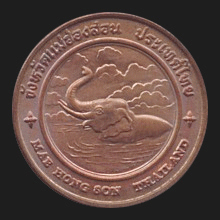
of Chiang Mai, to capture the wild elephants that inhabited the
forested mountains of the region. He built a post from where he
could operate his expedition which later grew into the present-day
town. The
place-name is possibly derived, though with a different Thai spelling, from the
name of an elephant training camp, that is an enclosed space or
‘room’ (hong
- ห้อง) in between two mountains, in a
valley several kilometers south of the city where wild elephants were formerly
rounded up, tamed and ‘trained’ (son - สอน). The name Mae (แม่)
which means ‘mother’, is also a general name for any village or
small city in North Thailand and appears in many place-names. It is
likely an abbreviation of Mae Nahm,
the Thai word for ‘river’
which literally means ‘mother
of the water’, as many villages are situated on river banks and
their name often derives from the river they are located at, akin to
the Central Thai word
Bang,
e.g. the northern city of Mae Taeng which is located at the
Mae Taeng River or Mae Nahm Taeng, in Thai. Besides
this, the name Mae (‘mother’) might also be understood as an
allegorical reference to a place where one feels at home.
Another story says that the dwelling near the
elephant training camp was first called Ban Mae Rong Son (บ้านแม่ร่องสอน)
with Ban, meaning ‘dwelling’ or ‘village’ and Rong being a ‘groove’,
‘cavity’ or ‘corner’. This version states that the name Mae Rong Son
was corrupted to Mae Hong Son, as the initial R is often pronounced
as H in the northern dialect of
Lan Na, e.g.
Chiang Rai
which is pronounced
Chiang Hai and the word Ban was dropped
altogether when the place grew into a larger town. Mae Hong Son
prospered and Shan began migrating there in increased numbers. In
approximately 1856 political unrest arose on the western banks of
the
Salawin river, causing further influx of Shan who fled the
troubled area, and again in 1876 war broke out between the
principalities of Meuang Nai (เมืองนาย) and Meuang Mok Mai (เมืองหมอกใหม่)
in which prince Kolan (โกหล่าน) of Mok Mai, unable to sustain the
battle, fled with his family and peers to Mae
Hong Son. With this constant influx of migrants Mae Hong Son had by
1874 become a large community and changed it status from a
village to a
meuang. A
phaya
was appointed and from then onward the
area and town were governed by successive rulers,
the first being
the Shan leader
Singha Nat Racha
(fig.). In 1890, during the
reign of king
Rama V, several partially
independent city-states in the region, including Mae Hong Son, Khun
Yuam, Mae Sariang and Pai
were incorporated into one
single unit of government, named Boriwen Chiang Mai Tawantok (บริเวณเชียงใหม่ตะวันตก),
i.e. ‘Chiang Mai's Western Precinct’ which in 1903 was
renamed Boriwen Phayap Neua (บริเวณพายัพเหนือ),
the ‘Northwestern Precinct’ and in 1910 made into a Thai
province by royal decree, with
the town of Mae Hong Son (fig.) as the administrative capital.
Places of interest
include
Wat Jong
Kham and
Wat Jong
Klang, two temples
in Burmese style (map
- fig.) near the lake in the centre of town (fig.); Tham Pla fish cave (map
- fig.);
Nahm Phiang Din Cave (map
-
fig.);
Tham Lod cave (map
-
fig.)
with a river running
through (fig.)
and the separate section of
Tham
Phi
Maen (fig.);
Pha Bong
viewpoint (map
-
fig.), Kiw Lom (กิ่วลม)
viewpoint
(map
-
fig.)
and
Lisu
market;
Pai Memorial Bridge (map
- fig.); and
Wat Phrathat Doi Kong Moo
(fig.),
a hilltop temple offering an excellent view over
the city (fig.)
and the northern valley (fig.)
with the Provincial Prison (map
-
fig.). This province of 7
amphur
is known for its
Poi Sang Long festival
(fig.),
Bua Thong Flower Blooming Season
festival (fig.)
and the
Longneck Karen
(fig.).
Its provincial flower is the tithonia diversifolia
(fig.).
See also
Mae Hong Son data file.
See MAP.
回


|

