|
Bangkok (บางกอก)
Thai-Western name for
Krung Thep
(fig.),
the contemporary capital of Thailand on the estuary of the
Chao Phraya
River.
Initially, Bangkok was
administered as a province, overseen by the
Krasuang Nakhonbahn,
but in 1975 its status was changed into
that of a metropolis, and the BMA or Bangkok Metropolitan
Administration was founded, which is headed by an elected governor
with a four year term and oversees a number of agencies and
services. Bangkok covers an area of 1,568.7 km² and is bordered by
the Gulf of Thailand and
Samut Prakan
in the South,
Samut Sakon
and
Nonthaburi
in the West,
Pathum Thani
in the North and
Chachengsao
in the East. The name is composed of the words
bang (a
riverside village) and
makok
(fig.),
and refers to a place north of today's centre where the capital was
formerly founded. Bangkok (map)
is divided into 5
amphur
(districts) and 45
khet
(zones), with Phra Nakhon at its centre. The khet or zones are again
divided in subdistricts called
khwaeng.
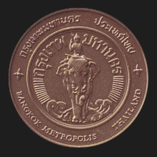
Although exact numbers are not available, it is sure that the
metropolis (fig.)
has at least ten million inhabitants; some sources even estimate
between 13 and 16 million. The main occupation of its people is
civil service, trade, business, industry and agriculture. Its main
places of interest
include
Phra
Rachawang
(fig.),
Wat Phra Kaew (fig.),
Jim Thompson's House
(fig.),
the
Marble Temple
(fig.),
Museum of Sciences and Planetarium
(fig.),
the
National Museum
(fig.),
Wat Arun
(fig.),
Wat Traimit
(fig.),
the Miniature Boat Museum (map
- fig.),
Discovery Museum (fig.),
King
Rama IX Royal
Park (fig.),
King
Rama I Statue (map
- fig.),
King
Rama VI
Statue (map
-
fig.),
King
Wachirawut
Monument (map
-
fig.)
and King
Rama VIII
Statue (map
-
fig.),
Ratchada bronze statues (map
- fig.),
Ramkamhaeng
bronze statues (map
- fig.),
the Thai Naval
Auditorium (map
-
fig.) which was specially built for
the 2003 APEC summit in Bangkok,
and the many areas with nightlife, including a lively music
scene, etc. The oldest part of the city, i.e. roughly the area
between the Chao Phraya River and the semi-circumventing
Khlong Rop Krung
city canal, and more
or less corresponding to today's
khet
Phra Nakhon (พระนคร), as well as the initial period of the Bangkok era,
is also referred to as
Rattanakosin
or Koh Rattanakosin,
i.e. ‘Rattanakosin
Island’, due to the surrounding water, whereas the art style from this area and period is known as Bangkok style. The city is also
nicknamed the
Big Mango, after the Big Apple and
derived from the Chinese name for Bangkok, i.e.
Mangu.
Bangkok's
coat of arms (fig.),
which also appears in white on the city's dark green flag (fig.),
features the Hindu deity
Indra
(fig.)
seated on the
elephant
Erawan (Airavata)
and holding a
trihsoon
(trident) and a
kho chang (elephant hook).
It refers to the Thai name for Bangkok (Krung Thep Maha Nakon)
in which occurs the sentence
‘Impregnable
Stronghold
of the
god
Indra’, whilst the
elephant Erawan is the official
mount of Indra, whilst the elephant in the logo of Bangkok has four tusks (fig.).
There
are also two canals that carry the name Bangkok in their label,
i.e. Khlong Bangkok
Yai(คลองบางกอกใหญ่)
and
Khlong
Bangkok
Noi (คลองบางกอกน้อย),
i.e. the
‘Large
Bangkok
Canal’ and ‘Minor
Bangkok Canal’,
or the ‘Greater Bangkok Canal’ and ‘Lesser
Bangkok Canal’,
respectively, both in
Thonburi. See
also
Bangkok data file.
WATCH VIDEO (1)
and
(2),
and
VIDEO (M).
回


|